Saturday, April 29, 2006

Busy Day of Baseball

Saturday's Games:

Matt's Vinemont team lost both ends of their doubleheader with Good Hope. They lost game one 15-4, with Matt going 1/2 with one run scored. They lost game two 10-9, with Matt going 0/2. Matt played 3B.

Joe's Vinemont team also lost both ends of their doubleheader with Good Hope. They lost game one 10-5. Joe played CF and went 0/1. They lost game two 9-6 and Joe went 1/2 with one run scored and he played 3B.

David's Vinemont team lost to Good Hope 16-11. David was 2/2 and also walked one time. David played LF.


David ropes one to the opposite field


David is brushed back


David's team photo


Joe lines a single in the hole between SS and 3B


Joe played 3B


Joe scores Vinemont's final run

Joe's team picture

Matt lines one foul down the line

Matt makes the play at 3B

Matt tomahawks one

Matt's team picture


Matt plays around waiting for the team picture

Today is a busy schedule:

8 a.m. - Matt's team pictures

10 a.m. - Joe's team pictures

10 a.m. - Matt's game vs. Good Hope

11 a.m. - Matt's 2nd game vs. Good Hope

Noon - Joe's game vs. Good Hope

2:45 p.m. - Joe's 2nd game vs. Good Hope

3:00 - David's team pictures

4:30 - David's game vs. Good Hope

6 p.m. - Safe at home, hopefully!

Baileyton 10 Vinemont 2

David's Vinemont team traveled to Baileyton in NE Cullman County last night and played at 7:30. David played two innings at second base. He did well, fielding cleanly the only ball hit to him. He didn't get to bat.

David's Vinemont team is now 0-2 on the year and he is 0/2 in batting.

Wednesday, April 26, 2006

A Political Poll...

I don't think this is very scientific, but it is fun. I think the results are generally true, but not exactly. I am much more conservative on personal responsibility issues than this poll indicates. This poll doesn't ask enough questions in a clear manner. Try it anyway. It's fun and thought-provoking!

Your Political Profile

Overall: 80% Conservative, 20% Liberal
Social Issues: 100% Conservative, 0% Liberal
Personal Responsibility: 50% Conservative, 50% Liberal
Fiscal Issues: 100% Conservative, 0% Liberal
Ethics: 75% Conservative, 25% Liberal
Defense and Crime: 75% Conservative, 25% Liberal

How Liberal / Conservative Are You?

"Be Kind Anyway" by Mother Teresa

People are often unreasonable, illogical, and self-centered;
Forgive them anyway.

If you are kind, people may accuse you of selfish, ulterior motives;
Be kind anyway.

If you are successful, you will win some false friends and some true
enemies; Succeed anyway.

If you are honest and frank, people may cheat you;
Be honest and frank anyway.

What you spend years building, someone could destroy overnight;
Build anyway.

If you find serenity and happiness, they may be jealous;
Be happy anyway.

The good you do today, people will often forget tomorrow;
Do good anyway.

Give the world the best you have, and it may never be enough;
Give the world the best you've got anyway.

You see, in the final analysis, it is between you and God;
It was never between you and them anyway.

Tuesday, April 25, 2006

Vinemont Lost Two

Matthew had a doubleheader tonight. Unfortunately, Matt's team, Vinemont, lost both games. West Point defeated Vinemont 10-9 in game one and 16-2 in game two. Matt was 2/2 in game one, scoring two runs, and 0/1 in game two.

Matt's team is now 0-3 on the season. Matt is 2/4 on the season (.500) with two runs scored.


Monday, April 24, 2006

It Was 20 Years Ago...

I debated whether I should post this photo, but I will in honor of UA Chi Alpha's 20th anniversary.


City Cafe, Northport, AL, Circa 1986

Vinemont 18 Fairview 6

Joe's team defeated Fairview tonight 18-6. Joe was 2/2 with a 2-run "inside the park" home run. Here's a photo of Joe taken after the game.

UA Chi Alpha 20 Year Reunion Photos, Part 2

Below are some more photos taken at our fellowship's 20th anniversary this past weekend. I had an awesome time visiting with some of the best friends of my life, worshipping God, and meeting people who came after me. Chi Alpha Campus Ministry has been truly "active" at the University of Alabama since Al and Heather Baker arrived as campus pastors in 1986. They pastored until 1996, when Shane and Shelly Dorrill took over leadership responsibilities. This year, my friends Craig and April Woodham will be the new pastors.


John and Al


Chip


Al


Craig, Al, and Josh


Tom and Cheryl


Greg and Kandi


April and Craig

Retirement of Judge Bibb

Morgan County District/Juvenile Court Judge David Bibb retired Friday April 21. Here is an article from the Decatur Daily. Below are two photos taken of the event with my camera.


Judge Bibb looks at a scrapbook presented by our unit.


Me and members of my unit present Judge Bibb with a scrapbook highlighting the 25 years he has worked with our unit.

Opening Day 2006


Joe


David


Joe


Matt

Opening Day

On Saturday April 22, 2006, the boys all had opening day of the 2006 baseball season. Vinemont played at Good Hope in all three games involving my boys. In the afternoon, Matt's team lost to Good Hope 13-0. Matt went 0/1 and played OF and 1B. In the evening, David's team defeated Good Hope 9-8. David played right field and went 0/2. In the nightcap, Joe's team lost to Good Hope 6-5 in extra innings. Joe went 1/1 and played right field.

Saturday, April 22, 2006

UA Chi Alpha 20 Year Reunion Photos


Craig, April, Al, Hope


Al and James


Oldie Moldies?

OK, Where Do I Begin?

I haven't kept up this blog as well as I would prefer this month. I guess it has been one of those months that I have been so busy living the dream that I haven't had enough time to write about it! Here are a few highlights:

Saturday April 1, 2006... A-Day Game with the boys...

April 7-8, 2006... Severe Wx in TN and AL... killer tornadoes in TN and 16 F1-F0 tornadoes in AL...first ever high risk issued by SPC for day two...

Throughout April... Baseball practices galore with all three boys...

Sunday April 16, 2006... Easter... hanging out with my parents and the egg hunt with the boys...

"Normal" times with the boys... homework, playing, working, cooking, cleaning, etc...

Buying a shirts for the boys and giving those "surprises"... Davis loved the Sosa jersey I got off Ebay...

Tuesday, April 18, 2006... Field trip with David and the 6th grade at VMS to US Space and Rocket Center.... being in charge of 10 boys for 6 hours ....

Thurs April 20.... A week of severe weather, especially hail, hit its peak in Vinemont...

Friday April 21... A huge day.... Judge Bibb's retirement.... our unit presented him a scrapbook that he really liked .... a huge day in the history of my office....

... Fri night.... One of the best times of my life! Sweet fellowship and worship with my "oldie moldie" friends from Chi Alpha... I'll have to write more later!

Saturday April 22, 2006... More Chi Alpha blessings.... My friend Tom and I ran into an old friend at the Rama Jama on our way over to the quad for a picnic... I saw sooo many wonderful friends from 15-20 years ago!

More April 22, 2006.... After driving Tom home, I watched my boys' first baseball games of the year in Good Hope.... unfortunately I missed my first and only game, ever, of any of the kids... Matt's team lost to Good Hope 13-0 and he went 0 for 1.... I saw David and Joe's games.... David's team defeated GH 9-8 (David was 0 for 2) and Joe's team lost to GH in extra innings 6-5 (Joe went 1 for 2)....

Wow, what a month so far...and I have only touched on the tip of the iceberg.

Wednesday, April 19, 2006

Braves' Best Fan

Pearl Sandow, chosen by the Atlanta Braves as their most loyal fan, died Monday at age 103. I wrote an article about Ms. Sandow when I was a teenager that was printed in the Huntsville Times. She was a special person.

AJC.com

AtlantaBraves.com

Friday, April 14, 2006

Precious Moments...

Precious Moments... I had several of those last night with the boys. You never know exactly what you will get with kids from one day to the next. Sometimes you are on top of the world and sometimes it's a struggle, but it's always a blessing. I am enjoying the adventure that comes with raising three boys. On the way home from work, I got a call from Joe, my 10 year old. He wanted to go with his friend to visit a karate class in Arab. The boys don't ask to do things away from me too often. We usually stick together like glue during the time that they are with me, which is about half of the year, since their mother and I are divorced. Because I only have them half the time, I call them each and every day they are not with me. I am fortunate that many of the days they are not "not with me", they really are with me because we are at practice together or school events together. I say all of that to point out why I am very reluctant to let my boys go. I'm not selfish about it, and I don't have a problem with it occasionally, as they get older. I told Joe to find out what time that he would be back and to ask to his Mom if she would let them stay with me Sunday night to make up for it. Sunday night is supposed to be her night with them. I thought and prayed about it until he called me back. I decided that if they could stay with me Sunday night that I would let him go. When Joe called me back, I told him that he could go, but that he needed to know that I missed him and that I was only saying yes because his mom agreed to let him stay with me Sunday night. He was glad.

When I got home, things were a bit crazy with too much going on at once. It was a "dramatic" day at work, and stress at home was not really on my agenda. Actually the boys were pretty well behaved. It was just a rush. I had to make something quick for supper (it was a frozen pizza night!) I was trying to get the boys to start mowing. Well the bolts that hold the gas tank in place were missing. Don't ask me how that happened on a relatively new mower! So, I was trying to fix that, keep the pizza from burning, and telling the boys to pick up the junk they just dropped in the living room floor as soon as they got home. Joe, being the mechanically-inclined child that he is, helped me find bolts to fit. Matt, age 7, took the initiative and found a flashlight to shine on the bolt. No, I didn't need the light on a sunny afternoon, but my heart melted at Matt's eagerness to find a way to help. I didn't have the heart to tell him that I didn't need the light. That flashlight battery was not wasted because Matt felt like he was helping. I couldn't find my socket wrenches, so David and Joe looked for those while I tried to make due without them. Finally I got the mower fixed, but it flooded. Then I got the pizza out just before it burned, and we all ate together. We had Klondike bars for dessert. That was probably our biggest "sin" of the night. Anyway, after we ate, Joe tried to call his friend who for some reason never showed up. I thought that Joe might be disappointed, and he was, but we had so much fun the rest of the night that he forgot his disappointment. David volunteered to prune the low-hanging branches on the trees and bushes in our yard. I was ok with that, but I told him, "As long as you pick up the branches and put them in the burn pile." The boys like to prune more than they like to pick up the branches. I can't say that I blame them. I feel fortunate that they just want to help at all without asking. I guess David decided that this was more fun than what I told him earlier in the evening. I told him that we were going to start a "four-man rotation" for toilet cleaning duty. David's response (he is age 12, going on teenager) was, and I quote, "That's sick." My response to that was, "David, what's more sick, taking turns making sure the toilet is clean or letting it go without anyone ever cleaning it?" Then I proceeded to give him my speech about how my first employer in high school was the UAH Preschool Learning Center. One of my main tasks was cleaning a bunch of toilets for preschoolers with bad aim. Then my speech segued into why he needed to buckle down in school so that he could do something "less sick" for a job in the future. He took it well. Sometimes I just can't help myself during those "teachable moments".

I really made the day of the three little firebugs when I proclaimed it was high time that we set fire to the massive burn pile in the back yard. Yes, we live in the country. We had a huge stack of limbs that had blown down during the past year or so, including many from the remnants of Hurricane Katrina. Our brown Christmas tree was also in there somewhere. We also tossed some boxes that had been junking up my storage room for way too long. So, we pulled out the hose, grabbed some matches, and set a fire. Fires are fascinating. The boys were saying things like, "look how it makes a funnel like a tornado." Joe, always looking for a job to do, volunteered to rake out the remnants of an ant bed that I destroyed with Clorox bleach last week. Matt and I played catch. After the fire died down, we went in for the evening. The boys had begged to watch the movie, "Pirates of the Caribbean" with me. I denied the request, saying that we would be up past 11 if we tried to do that. We did watch portions of the Braves-Phillies game. Once again, I forgot to watch "The Office". I have friends who keep telling me how much I would like that show, but Thursdays are just too busy and I'm not that much into the TV scene, except for weather, sports, and news. Probably the biggest fun was when we called the Chicago Cubs hotline. The Cubs have a telephone number that you can dial to request a pocket schedule by voice mail. Well, the boys made it their goal to make me laugh as I recorded my name and address. They really got me laughing when I called in a request for a schedule for my Mom. My mom is a lifelong Cubs fan and she told me that she would like to have a Cubs schedule mailed to her. Well, when in my deep baritone voice, I spoke her name, it was all I could do to not laugh. Then I got a little too silly. I told the boys to listen to my next call. In honor of David, our family's resident "Mr. Cub" and erstwhile Sammy Sosa fan, I called to request a schedule. When it asked for my name, I said, "Sammy Sosa", spelled S-O-S-A; gave my address as 708 Steroid Drive, san Pedro de Macoris, Dominican Republic. Then in my best Latin accent I said, sorry, we do not have zip codes in the Dominican. I also did one for everyone's favorite alleged steroid user, Barry Bonds. Yes, I know I was being silly, stupid, and childish, but we laughed so hard together! I just hope the Cubs don't track me down through caller ID. Who knows, maybe we made someone in Chicago have a laugh or two!

We watched a few cartoons, including "Rupert and the Frog Song", by Paul McCartney. Then I showed them this really cool clip from a McCartney DVD called "Chaos and Creation at Abbey Road". Paul shows how he composes music and lays down the track by himself. First he recorded a basic drum track. Then he proceeded to layer onto that piano, bass guitar, rhythm guitar, lead guitar, and vocals. We were all fascinated. I sent them to the bathroom to take their baths. Matthew was so sweet. After his bath he came back and cuddled up next to me on the couch. When I started to get up he held on to me like he didn't want me to go. The boys are going through some bad circumstances at their Mom's place, so that might explain why he was so clingy. It meant a lot to me, though, for him to need my comfort. I let David and Joe work on their fantasy baseball teams a little bit while I sat on the couch with Matt. I let Joe send in our Vinemont weather report to James Spann at ABC 33/40. He did it all by himself and all I did was check it for accuracy. We stayed up late enough to watch the news and weather at 10 p.m. on 33/40. We gave out high fives when James called out that the high in Vinemont in northern Cullman County was 80. As usual, we prayed before bed. We skipped the usual bedtime story, though, and crashed. It's a wonderful life! Thank you, Lord, for David, Joseph, and Matthew! As long as this entry is, it doesn't even capture so many other things that were said and done that were blessings to us all last night. These days are so precious to me and they will never come back again. My goal and highest calling in life is to make the most of this time and pour everything I have to offer into my sons' lives! That's all for now...

Monday, April 10, 2006

Visit With Dad

Last week I got to spend a little time with my Dad. We watched the Cubs defeat the Cardinals in Wrigley Field on WGN. Greg Maddux got his first win of the 2006 season. My Dad and I really enjoy watching sports together and always have. We talked about what a great pitcher Maddux was and how fun it is to watch him outsmart the other team rather than overpower the other them. We talked about the changes to Wrigley Field, including a "peep hole" where you can watch the game from ouside the stadium on Sheffield Avenue. I was telling the story the other day of my Dad taking me to my first Alabama game on October 25, 1975 in Legion Field against TCU. It was an awesome experience. Thanks to my Dad for so many great memories.


Greg Maddux at Turner Field in Atlanta, 7/4/05

Introducing a New Blog

I decided that I would take the weather content off this blog, since there was so much of it, and create a new blog for anyone interested in my "weather geek" stuff.

Alabama Weather Blog

Severe Weather Notes From 4/7/26

Friday, April 07, 2006

Severe Weather Info 4/7/06

I saw two amazing hail events...one near Hartselle and a few minutes later, at 10:49, I saw tennis ball sized hail one mile north of Falkville...

---

Tornado on the ground at hwy 150/400 just north of Courtland in Lawrence Co 9:07...

---

No new damage reports lately, but numerous reports of large hail. At about 8:50, there were reports of funnels and tornadoes sigted north of Hamilton near Hackelburg.

---

WAFF storm spotter Jeff Gray getting pelted by golfball sized hail on tha AL/TN line at 7:50 p.m.

---

"Major wall cloud" spotted by Spencer with WHNT, SW of Athens at 7:32...
...Spotter reports tornado in Ardmore... 7:36 p.m....

---

Debris near I-65 McDonalds at Athens exit, per WHNT TV

---

WHNT 19 is showing video of two possible funnel clouds...one on the Morgan/Lawrence line and one in northern Limestone...

---

Funnel Cloud near Coxey, Limestone Co, at 6:52, reported by amateur radio spotters.

---

Storms appear to be clustering in NW AL and rainfall area increasing...that would be encouraging news that instability might be decreasing in that area...

---

Power outages and large oak trees down in Colbert Co...per WAFF

---

Colbert EMA reports that people are trapped in the home in Colbert Heights, Underwood Mt Road, but they are ok. The New Bethel FD was on the way to help but were delayed by trees down on the road...

---

Damage Report: Colbert EMA reports barn damage 5835 Underwood Mt Rd, south of Tuscumbia...

---

Funnel Cloud forming out of the wall cloud near Florence on WAFF Shoals Tower Cam.

---

Things have blown up like crazy in MS since I last wrote. I travelled back to Cullman from Huntsville. There are now numerous tornado warnings in N MS and NW AL at this time (5:54 p.m.) WAFF reports that NWS reported a tornado on the ground in Lauderdale Co.

---

Death toll is now up to 7 in TN

---

Latest from the SPC...here is an exerpt from the latest convective outlook...There is a 60% probability of F2 or greater tornadoes within 25 miles of any given point in North AL. I've never seen an outlook with that high of a value, ever.


1930Z VISIBLE SATELLITE IMAGERY SHOWS AN EXPANDING CUMULUS FIELD
OVER NRN LA...SERN AR AND NW MS. AS LARGE-SCALE ASCENT INCREASES
AHEAD OF THE APPROACHING TROUGH...RAPID SUPERCELL INITIATION SHOULD
TAKE PLACE JUST AHEAD OF A LOW TO MID-LEVEL JET PUNCHING INTO THE
AREA. AS THE JET PUNCHES EWD ACROSS NRN MS AND NRN AL...SHEAR
PROFILES WILL BECOME VERY FAVORABLE FOR LONG-LIVED STRONG TORNADIC
SUPERCELLS. AN OUTBREAK OF STRONG TORNADOES SHOULD OCCUR ACROSS NRN
AND CNTRL MS...NRN AL AND SCNTRL TN. AS THE STORMS TRACK
ENEWD...SEVERAL LONG-LIVED VIOLENT TORNADOES NOW APPEAR INCREASINGLY
LIKELY AS A 50 KT LOW-LEVEL JET FEEDS NWD INTO THE TORNADIC STORMS
ACROSS NRN MS...NRN AL AND SCNTRL TN. THE THREAT OF STRONG TO
VIOLENT TORNADOES WILL CONTINUE AS INTENSE TORNADIC SUPERCELLS MOVE
ENEWD THIS AFTERNOON ACROSS SRN TN...NRN AL AND POSSIBLE AS FAR EAST
AS NWRN GA.


---

People just south of Nashville need to take cover as a monster supercell is headed up I40 towards Davidson County.

---

From Jackson, MS...
BULLETIN - EAS ACTIVATION REQUESTED TORNADO WARNING NATIONAL WEATHER SERVICE JACKSON MS 348 PM CDT FRI APR 7 2006 THE NATIONAL WEATHER SERVICE IN JACKSON HAS ISSUED A * TORNADO WARNING FOR... NORTHERN MOREHOUSE PARISH IN NORTHEAST LOUISIANA THIS INCLUDES THE CITY OF BASTROP * UNTIL 445 PM CDT * AT 348 PM CDT...NATIONAL WEATHER SERVICE DOPPLER RADAR INDICATED A SEVERE THUNDERSTORM CAPABLE OF PRODUCING A TORNADO 12 MILES WEST OF BASTROP...MOVING EAST AT 55 MPH. * THE TORNADO IS EXPECTED TO BE NEAR... BASTROP BY 355 PM CDT... IN ADDITION TO THE TORNADO...THIS STORM IS CAPABLE OF PRODUCING BASEBALL OR LARGER SIZE HAIL AND DESTRUCTIVE STRAIGHT LINE WINDS. SPOTTERS HAVE REPORTED A FUNNEL CLOUD WITH THIS STORM OVER UNION PARISH.

---

Monster Supercell west of Nashville now on I40 at 3:52. This cell was a small, thin east-west mini-line when it developed east of Memphis. Once it moved into a more favorable environment it exploded into a huge supercel. There are now tornado warnings with this cell.

---

Tornado emergency for SE Williamson and Maury Co., TN according to WTVF, Nashville. 3:43 p.m.

---

Check this out from NSV NWS...
BULLETIN - EAS ACTIVATION REQUESTED TORNADO WARNING NATIONAL WEATHER SERVICE NASHVILLE TN ISSUED BY NATIONAL WEATHER SERVICE MORRISTOWN TN 325 PM CDT FRI APR 7 2006 THE NATIONAL WEATHER SERVICE IN NASHVILLE HAS ISSUED A * TORNADO WARNING FOR... BEDFORD COUNTY IN MIDDLE TENNESSEE MARSHALL COUNTY IN MIDDLE TENNESSEE MAURY COUNTY IN MIDDLE TENNESSEE THIS INCLUDES THE CITY OF COLUMBIA RUTHERFORD COUNTY IN MIDDLE TENNESSEE WILLIAMSON COUNTY IN MIDDLE TENNESSEE * UNTIL 415 PM CDT * AT 321 PM CDT...NATIONAL WEATHER SERVICE DOPPLER RADAR WAS TRACKING A LARGE AND EXTREMELY DANGEROUS TORNADO NEAR COLUMBIA...MOVING EAST AT 40 MPH. THIS IS AN EXTREMELY DANGEROUS SITUATION. TAKE COVER NOW!!

---

Storms now firing in north MS 3:15 pm ...

---

AT 304 PM CDT...TRAINED WEATHER SPOTTERS REPORTED A TORNADO 11 MILES SOUTHWEST OF EDMONTON, KY...MOVING EAST AT 60 MPH.

---

Tornado on the ground near Cincinnati

Tornado on the ground I65 Near Louisville, KY near Sellersville...

Tornadoes are on the ground now as far north as Indiana.

---

Storms are now firing in NE Louisiana. These will later blossom into supercells and roll through MS and AL. These storms will increase in severity and coverage. I expect that these can spawn large long track tornadoes.

---

Damage in Gallatin and people trapped in the Volunteer State Community College. Minor injuries reported at this time. Another possible headed toward Gallatin.

---

Tornado on the ground just north of Nashville, near exit 97, Goodletsville. Damage in Charlotte, TN


Tornado Warning, Carroll Co. TN - First Report of a tornado so far today.

---

PUBLIC SEVERE WEATHER OUTLOOK
NWS STORM PREDICTION CENTER NORMAN OK
1217 PM CDT FRI APR 07 2006

...OUTBREAK OF SEVERE THUNDERSTORMS AND TORNADOES EXPECTED OVER
PARTS OF THE LOWER/MIDDLE MISSISSIPPI VALLEY....TENNESSEE/OHIO
VALLEYS AND SOUTHERN APPALACHIANS THIS AFTERNOON AND TONIGHT...

THE NWS STORM PREDICTION CENTER IN NORMAN OK IS FORECASTING THE
DEVELOPMENT OF WIDESPREAD SEVERE STORMS INCLUDING A FEW
STRONG...LONG-TRACK TORNADOES OVER PARTS OF MISSISSIPPI...
ALABAMA...AND TENNESSEE.

THE AREAS MOST LIKELY TO EXPERIENCE THIS ACTIVITY INCLUDE

NORTHERN ALABAMA
NORTHERN MISSISSIPPI
WESTERN AND MIDDLE TENNESSEE

SURROUNDING THE HIGH RISK AREA...THERE IS A MODERATE RISK OF SEVERE
THUNDERSTORMS FROM THE LOWER MISSISSIPPI VALLEY NORTHEASTWARD INTO
THE OHIO VALLEY AND SOUTHERN APPALACHIANS

AN UPPER STORM SYSTEM OVER THE CENTRAL PLAINS WILL MOVE SEWD TOWARDS
THE LOWER MISSISSIPPI VALLEY TODAY AND TONIGHT. IN ADVANCE OF THIS
SYSTEM...BROAD LOW LEVEL LIFT COMBINED WITH INCREASING LOW LEVEL
MOISTURE AND INSTABILITY WILL CONTINUE TO SUPPORT THE DEVELOPMENT OF
SCATTERED THUNDERSTORMS FROM THE LOWER MISSISSIPPI AND TENNESSEE
VALLEYS NORTHEASTWARD INTO THE OHIO VALLEY AND SOUTHERN APPALACHIANS
THIS AFTERNOON THROUGH TONIGHT. STRONG LOW-MID LEVEL WIND FIELDS
COMBINED WITH MODERATE TO VERY STRONG INSTABILITY WILL SUPPORT
SUPERCELL STORMS WITH THE LIKELIHOOD FOR TORNADOES /SOME POTENTIALLY
VIOLENT/...VERY LARGE HAIL AND DAMAGING WINDS.

ONGOING SEVERE SUPERCELL STORMS ACROSS WESTERN TENNESSEE AND WESTERN
KENTUCKY WILL REMAIN CAPABLE OF PRODUCING TORNADOES...VERY LARGE
HAIL AND STRONG...DAMAGING WINDS.

EXCEPTIONALLY STRONG LOW LEVEL WIND SHEAR OVER PORTIONS OF THE
TENNESSEE AND LOWER MISSISSIPPI VALLEYS WILL AID IN THE POTENTIAL
FOR A FEW LONG-TRACK STRONG TORNADOES WITH THE SUPERCELL
THUNDERSTORMS. THE HIGHEST RISK OF STRONG LONG-TRACK TORNADOES WILL
BE FROM NORTHERN MISSISSIPPI/WESTERN TENNESSEE EASTWARD THROUGH
MIDDLE TENNESSEE AND NORTHERN ALABAMA THIS AFTERNOON INTO THE
EVENING.

THIS IS POTENTIALLY A VERY DANGEROUS SITUATION. THOSE IN THE
THREATENED AREA ARE URGED TO REVIEW SEVERE WEATHER SAFETY RULES AND
TO LISTEN TO RADIO...TELEVISION...AND NOAA WEATHER RADIO FOR
POSSIBLE WATCHES...WARNINGS...AND STATEMENTS LATER TODAY.

..PETERS/HALES.. 04/07/2006


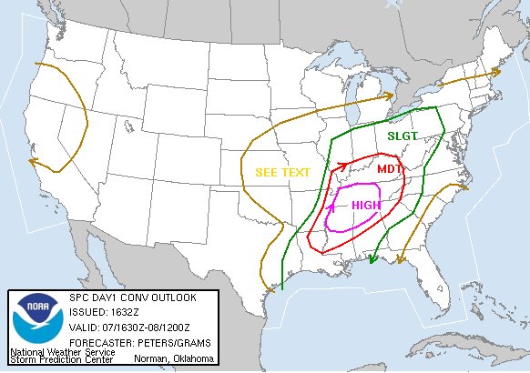
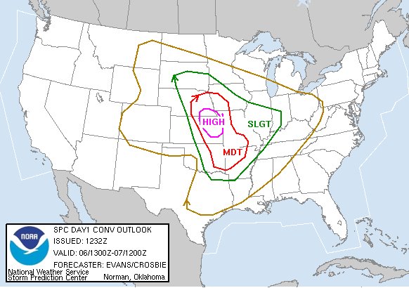
SPC Latest Outlook - High Risk Expanded
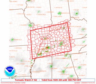

PDS Tornado Watch #163
PDS Tornado Watch Issued for Alabama


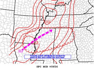
MESOSCALE DISCUSSION #454

Storms are firing rapidly between Pine Bluff, AR and Memphis and especially between Memphis and Clarksville, TN at 10:43.

It has been mostly sunny in Decatur all morning. I walked at 10-10:15 and it was also very muggy and very windy. It feels like the humidity has really increased.


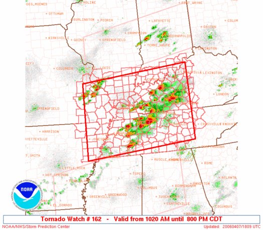
First Tornado Watch of the Day


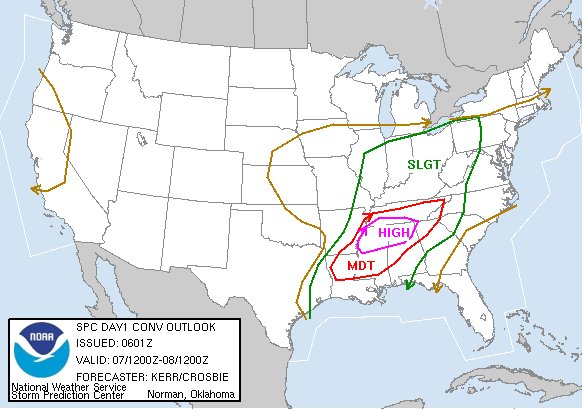
Tornado Outlook, SPC, 7:16 a.m. 4/7/06


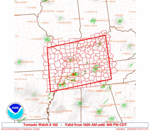
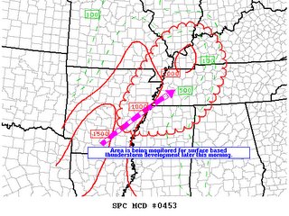
Storms are already firing in northwest MS and western TN. by 8 am.
MESOSCALE DISCUSSION 0453

Here is one of the best sites to stay weather aware throughout the day.

Public Severe Weather Outlook

http://www.spc.noaa.gov/products/outlook/pwo.html

High Risk Today in North MS and North AL, South TN


SPC AC 070601 DAY 1 CONVECTIVE OUTLOOK NWS STORM PREDICTION CENTER NORMAN OK 0101 AM CDT FRI APR 07 2006 VALID 071200Z - 081200Z ...THERE IS A HIGH RISK OF SVR TSTMS TODAY ACROSS MUCH OF NRN MS...NRN AL...AND PARTS OF SRN TN. THIS INCLUDES THE MEMPHIS TN/TUPELO MS AREAS EASTWARD INTO BIRMINGHAM AL AND CHATTANOOGA ...WHICH SEEMS LIKELY TO BE AT THE FOCUS FOR AN OUTBREAK OF SEVERE THUNDERSTORMS...INCLUDING THE RISK FOR SUPERCELLS WITH TORNADOES.... ...THERE IS A MDT RISK OF SVR TSTMS TODAY INTO TONIGHT THROUGH A LARGE PORTION OF THE LOWER MISSISSIPPI VALLEY THROUGH THE TN VLY/SRN APPALACHIANS.... ...THERE IS A SLGT RISK OF SVR TSTMS SURROUNDING THE MODERATE AND HIGH RISK AREAS...ACROSS MUCH OF THE NATION EAST OF THE MS RIVER INTO THE APPALACHIANS.... THE LARGE-SCALE UPPER FLOW PATTERN HAS BECOME A BIT LESS PROGRESSIVE...BUT MODELS INDICATE THAT THE CENTRAL PLAINS CLOSED LOW WILL GRADUALLY EVOLVE INTO AN OPEN WAVE AND TURN SOUTHEASTWARD TODAY...LIKELY ADVANCING THROUGH MUCH OF THE LOWER MISSISSIPPI VALLEY BY 12Z SATURDAY. THIS IS FORECAST IN RESPONSE TO A SIGNIFICANT SMALLER SCALE IMPULSE ROTATING AROUND ITS SOUTHWESTERN/SOUTHERN PERIPHERY...AND FORCING ASSOCIATED WITH A NORTHERN STREAM TROUGH...WHICH WILL DIG THROUGH THE GREAT LAKES REGION. AS THIS OCCURS...A BROAD BELT OF STRONG CYCLONIC MID/UPPER FLOW IS PROGGED TO CONTINUE TO GRADUALLY OVERSPREAD MUCH OF THE GULF COAST STATES AND MID SOUTH INTO THE NORTHEAST. STRENGTHENING WIND FIELDS/SHEAR PROFILES WILL BECOME JUXTAPOSED WITH A RETURN FLOW OF BOUNDARY LAYER MOISTURE FROM THE WESTERN GULF OF MEXICO...THROUGH A BROAD AREA FROM THE LOWER/MIDDLE MISSISSIPPI VALLEY INTO THE APPALACHIANS. THIS IS EXPECTED TO SUPPORT INCREASING CONVECTIVE POTENTIAL...INCLUDING RISK FOR SEVERE STORMS...WHICH COULD BECOME FAIRLY NUMEROUS AND INTENSE BY THE AFTERNOON/EVENING HOURS. OTHER THUNDERSTORM ACTIVITY APPEARS POSSIBLE INTO CENTRAL PACIFIC COASTAL AREAS. APPROACHING UPPER TROUGH IS FORECAST TO GENERALLY REMAIN OFFSHORE...BUT MODELS INDICATE A FAIRLY SIGNIFICANT IMPULSE WILL PIVOT AROUND ITS EASTERN PERIPHERY...ACROSS THE CALIFORNIA COAST THROUGH THE SIERRA NEVADA BY THE END OF THE FORECAST PERIOD. ...LOWER MISSISSIPPI VALLEY THROUGH SOUTHERN APPALACHIANS... MODELS SUGGEST LEADING EDGE OF MID-LEVEL COOLING ASSOCIATED WITH THE PLAINS SYSTEM WILL OVERSPREAD MUCH OF THE REGION BY MID DAY. THIS WILL WEAKEN INHIBITION...AND SURFACE HEATING MAY BE ENOUGH TO INITIATE AT LEAST SCATTERED VIGOROUS CONVECTIVE DEVELOPMENT AS BOUNDARY LAYER DEW POINTS CLIMB THROUGH THE 60S. AS MIXED LAYER CAPE INCREASES IN EXCESS OF 2000 J/KG...STRONG DEEP LAYER SHEAR WILL BE SUPPORTIVE OF SUPERCELLS. CONFLUENT REGIME ASSOCIATED WITH 30 TO 40 KT SOUTHWESTERLY LOW-LEVEL JET SEEMS A LIKELY FOCUS FOR ACTIVITY...FROM PARTS OF CENTRAL/SOUTHERN MISSISSIPPI THROUGH EASTERN TENNESSEE. SOME OF THESE SUPERCELLS MAY BECOME LONG-LIVED...AND MODELS SUGGEST SUBSTANTIALLY LARGE/CLOCKWISE CURVED HODOGRAPHS ALONG THIS AXIS TO SUPPORT POTENTIAL FOR A FEW STRONG TORNADOES. WITH THE APPROACH OF DIGGING UPPER TROUGH...STRENGTHENING MID/UPPER FORCING IS EXPECTED TO SUPPORT INCREASINGLY WIDESPREAD SEVERE THUNDERSTORMS FROM THE LOWER MISSISSIPPI VALLEY INTO MIDDLE TENNESSEE LATE THIS AFTERNOON INTO THE EVENING HOURS. ACTIVITY MAY BE SLOW TO WEAKEN AS STRONGER FORCING SHIFTS TOWARD THE SOUTHERN APPALACHIANS OVERNIGHT. ...OHIO VALLEY... DEFORMATION ZONE BETWEEN NORTHERN AND SOUTHERN STREAM IMPULSES APPEARS TO BE A LIKELY FOCUS FOR CONVECTIVE DEVELOPMENT TODAY. MODELS SUGGEST FAIRLY STRONG SURFACE HEATING WILL OCCUR ALONG AN AXIS FROM THE ST. LOUIS AREA EASTWARD THROUGH SOUTHERN OHIO... WHICH SHOULD SUPPORT WEAK TO MODERATE DESTABILIZATION AHEAD OF DEVELOPING/STRENGTHENING BAROCLINIC ZONE. FRONTAL ZONE IS PROGGED TO SURGE SOUTH OF THE GREAT LAKES REGION EARLY THIS AFTERNOON... THROUGH MUCH OF THE OHIO VALLEY BY EARLY EVENING. THIS FORCING IS EXPECTED TO BECOME SUFFICIENT FOR AN EVOLVING SQUALL LINE...WITH MIXED LAYER CAPE ON THE ORDER OF 1000 J/KG SUPPORTIVE OF VIGOROUS UPDRAFTS IN STRONG AND SHEARED WESTERLY FLOW. IN ADDITION TO LARGE HAIL...DAMAGING WIND GUSTS COULD BECOME FAIRLY NUMEROUS BY/ SHORTLY AFTER PEAK HEATING. ..KERR/CROSBIE.. 04/07/2006

Thursday, April 06, 2006

High Risk of Severe Weather, North Alabama, 4/7/06

I think this is the first time the SPC ever issued a High Risk the day before the "event". The High Risk for North Alabama was first issued around noon today. I do not recall this ever having been done before. Also, if you look back at the SPC convective outlook for April 8, 1998, it is eerily similar to tomorrow's outlook.

Severe Weather in the Midwest Today


There is a high risk of severe weather in eastern Kansas today, as well as a large moderate risk area in much of the Midwest between Nebraska and Arkansas. Here is a portion of the Public Severe Weather Outlook from the Storm Predicion Center:

PUBLIC SEVERE WEATHER OUTLOOK NWS STORM PREDICTION CENTER NORMAN OK 0758 AM CDT THU APR 06 2006 ...AN OUTBREAK OF SEVERE THUNDERSTORMS PRODUCING VERY LARGE HAIL AND TORNADOES IS EXPECTED OVER PARTS OF THE EASTERN PORTIONS OF THE CENTRAL AND SOUTHERN PLAINS TODAY AND TONIGHT... THE NWS STORM PREDICTION CENTER IN NORMAN OK IS FORECASTING THE DEVELOPMENT OF TORNADOES...VERY LARGE HAIL AND DAMAGING WIND GUSTS OVER PARTS OF THE EASTERN PORTIONS OF THE CENTRAL AND SOUTHERN PLAINS TODAY AND TONIGHT. THE AREAS MOST LIKELY TO EXPERIENCE THIS ACTIVITY INCLUDE EASTERN KANSAS FAR NORTHWEST MISSOURI SOUTHEAST NEBRASKA SURROUNDING THE HIGH RISK AREA...THERE IS A MODERATE RISK OF SEVERE THUNDERSTORMS FROM EASTERN NEBRASKA AND WESTERN MISSOURI INTO EASTERN OKLAHOMA AND WESTERN ARKANSAS A DYNAMIC UPPER LEVEL STORM SYSTEM OVER THE CENTRAL ROCKIES THIS MORNING IS EXPECTED TO DEVELOP EASTWARD TOWARD KANSAS AND NEBRASKA THIS AFTERNOON AND TONIGHT. AS A RESULT...A SURFACE LOW PRESSURE WILL INTENSIFY ACROSS SOUTHERN NEBRASKA THIS AFTERNOON. TO THE SOUTH OF THE LOW...A DRYLINE WILL STRENGTHEN AND MOVE EASTWARD INTO THE EASTERN PORTIONS OF THE CENTRAL/SOUTHERN PLAINS. GULF OF MEXICO MOISTURE HAS BEEN ADVECTING NORTHWARD INTO THE PLAINS ON STRONG SOUTHERLY LOW-LEVEL WINDS THE PAST COUPLE OF DAYS. THIS WILL CONTRIBUTE TO AN UNSTABLE ENVIRONMENT SUPPORTIVE FOR THUNDERSTORMS. A STRONG WESTERLY FLOW ACCOMPANYING THE STORM SYSTEM WILL DEVELOP EASTWARD ACROSS THE CENTRAL AND SOUTHERN PLAINS EARLY TODAY... REACHING THE MID-MISSISSIPPI VALLEY AND MID-SOUTH BY THIS EVENING. THE STRONG FLOW ATOP THE SOUTHERLY FLOW AT THE SURFACE WILL BE CONDUCIVE FOR ORGANIZE STORMS INCLUDING SUPERCELLS........EVANS.. 04/06/2006

---

Tomorrow and tomorrow night those of us in Alabama need to be ready for a potentil outbreak of severe weather here. Here's a statement from the Birmingham NWS....

SPECIAL WEATHER STATEMENTNATIONAL WEATHER SERVICE BIRMINGHAM AL800 AM CDT THU APR 6 2006

...SEVERE WEATHER EXPECTED FRIDAY AND FRIDAY NIGHT...A POWERFUL STORM SYSTEM IS EXPECTED TO MOVE ACROSS THE MISSISSIPPIRIVER VALLEY EARLY FRIDAY RESULTING IN A CHANCE OF SEVERE WEATHERFRIDAY AND FRIDAY NIGHT ACROSS CENTRAL ALABAMA. DAMAGING WINDS...LARGE HAIL...HEAVY RAIN AND TORNADOES WILL ALL BE POSSIBLE. AT THISTIME...AREAS NORTHWEST OF A LINE FROM SELMA TO GADSDEN WOULD BEAFFECTED BEFORE MIDNIGHT...WITH THE FOCUS SHIFTING SOUTHEASTWARD ASTHE NIGHT CONTINUES.THIS IS A DEVELOPING SITUATION. STAY TUNED TO NOAA WEATHER RADIO ORA FAVORITE MEDIA OUTLET...OR VISIT OUR WEBSITE AT WEATHER.GOV/BMX...FOR THE LATEST INFORMATION ON THIS POTENTIALLY DANGEROUS EVENT.

And Huntsville NWS...

SPECIAL WEATHER STATEMENTNATIONAL WEATHER SERVICE HUNTSVILLE AL639 AM CDT THU APR 6 2006

...SEVERE WEATHER POSSIBLE FRIDAY AFTERNOON AND INTO SATURDAYMORNING...A STRONG STORM SYSTEM WILL BEGIN TO AFFECT THE TENNESSEE VALLEYFRIDAY WITH THE CHANCE OF SEVERE WEATHER. DAMAGING WINDS...LARGEHAIL...HEAVY RAIN AND A FEW TORNADOES WILL ALL BE POSSIBLE. THE BESTCHANCE OF SEVERE WEATHER WILL BE FROM FRIDAY AFTERNOON TO EARLYSATURDAY MORNING.STAY TUNED TO NOAA WEATHER RADIO OR A FAVORITE MEDIA OUTLET...ORVISIT OUR WEBSITE AT WEATHER.GOV/HUNTSVILLE...FOR THE LATESTINFORMATION ON THIS POTENTIAL SEVERE WEATHER EVENT.

Tuesday, April 04, 2006

Killer Tornadoes 4/2/06

UPDATE: 4/5/06 - Articles from The Tennessean


The following is some additional information about the tornadoes that struch the mid-South on Sunday afternoon and sunday night April 2, 2006.

Memphis National Weather Service - Storm Damage Surveys and Survey Photos

Little Rock National Weather Service - Severe Weather (March 30 - April 3, 2006)

Nashville National Weather Service - April 2, 2006 Storm Surveys

Paducah National Weather Service - Damage Assessments

St. Louis, National Weather Service - 02 April 2006 - Severe Thunderstorm Outbreak

Springfield, IL National Weather Service - Tornado Outbreak of April 2, 2006

Monday, April 03, 2006

Killer Tornadoes


I will be posting more later on the killer tornadoes that struck Tennesse and other locations yeaterday and overnight. Here is a link to information to view updates.

Fox News
CNN Story
AP Story
Jackson, TN Sun Story
The Tennessean Updated AP Story
ABC 33/40 Weather Talk Blog
Chicago Tribune
WREG Memphis